The Invisible Line: Crossing the Terminal Moraine
Featured:
There is a place in the Allegheny National Forest where the world changes in the span of a single step. To most drivers on Route 6 or hikers on the North Country Trail, the rolling hills and deep woods of the plateau seem uniform. But to those who know what to look for, there is an "Invisible Line"—the Terminal Moraine—that marks the exact point where a mile-high wall of ice finally ran out of steam.
This isn't just a bit of trivia; it is the fundamental dividing line of our geography. North of this line, you are standing on a landscape imported from Canada. South of it, you are standing on the ancient, weathered bones of Pennsylvania.
The Great Debris Pile
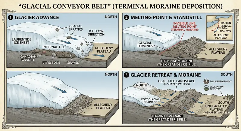
A glacier is not just a block of ice; it is a colossal conveyor belt. As the Laurentide Ice Sheet ground its way south from the Arctic, it plucked up everything in its path—boulders of pink granite from Ontario, limestone from the Great Lakes, and gravel from New York.
When the ice reached the edge of the Allegheny Plateau, the climate warmed just enough that the front of the glacier began to melt as fast as the ice behind it pushed forward. For centuries, the glacier stood still at this "melting point," dumping its entire cargo of Canadian stone into a massive, jagged ridge of debris.
This ridge is the Terminal Moraine. In our region, it roughly follows a line from the Tionesta area, curving north toward the Kinzua Dam.
How to Spot the Border
You don't need a degree in geology to find the edge of the Ice Age. You just need to look at the "Three S's":
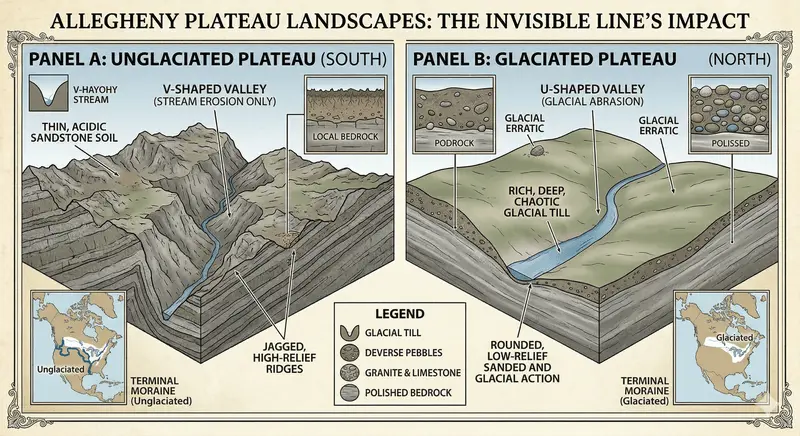
Stones: Look at the rocks in a creek bed. If you see rounded, smooth "foreign" stones like granite or quartzite (which don't naturally occur in our local sandstone layers), you are North of the line. These are "Glacial Erratics"—travelers from a thousand miles away.
Above:
Soil: South of the line, the soil is thin and acidic, made of broken-down local sandstone. North of the line, the soil is "Glacial Till"—a rich, deep, and chaotic mix of crushed rock and minerals brought down by the ice. This is why the farming is often better once you cross the moraine.
Shapes: South of the line, the hills are "V-shaped" and jagged, carved only by millions of years of rain. North of the line, the hills are "U-shaped" and rounded, literally "sanded down" by the weight of the ice passing over them.
The Edge of the World
The next time you are hiking the Tracy Ridge or driving toward Warren, pay attention to the stone walls and the shapes of the hollows. You are traveling across one of the most violent and dramatic borders in natural history. On one side, the plateau remained a frozen, wind-swept tundra; on the other, it was crushed and reshaped by a frozen hand.
The Terminal Moraine is more than a line on a map—it is the signature of the ice, written in stone and soil across the heart of the Kinzua country.