The "River Piracy" Part II: The Mystery of the Glacial Border
Featured:
We have previously explored how a colossal Ice Age dam blocked the northward flow of the ancient Allegheny River, turning it south in a dramatic act of "river piracy" (see Image: The Glacial Outburst Flood). But that catastrophic flood was only the beginning of the Ice Age’s impact on the Kinzua country.
The most profound legacy isn't the river's new path; it is the Invisible Line of the glacial border itself. In a region seemingly defined by endless, uniform timber, there is a distinct, physical point where the landscape fundamentally, instantly changes. To cross this line is to step over a prehistoric frontier.
The Great Debris Pile: What is a Terminal Moraine?
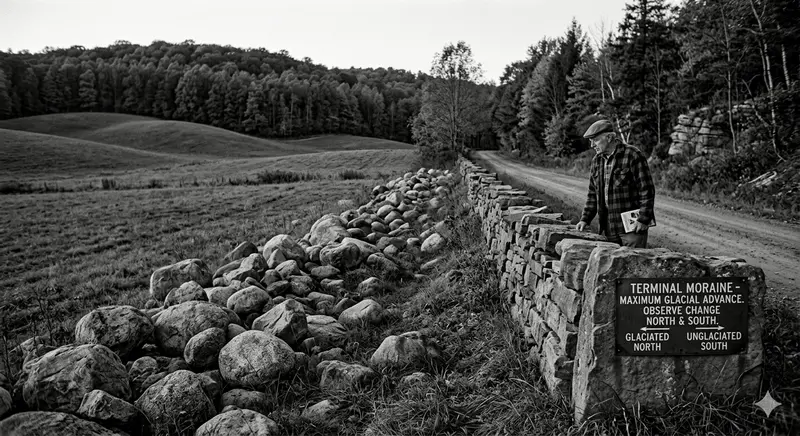
While the main body of the mile-high Laurentide Ice Sheet plowed southward from Canada, its edge finally halted right here on the Allegheny Plateau. Geologists call this maximum advance the "Terminal Moraine."
But what is a moraine? A glacier doesn't just push rock like a bulldozer; it functions as a vertical conveyor belt (see Image: The Glacial Conveyor Belt). As the ice flows forward from the Arctic, it incorporates massive boulders of Canadian granite, limestone, and gravel, plucking them from their beds and carrying them internally.
When the front of the ice reached the warming climate of our region, it began to melt at the exact same rate the glacier pushed forward. For centuries, the glacier stood still, perfectly balanced. As the ice melted into water, it "dumped" its entire conveyor belt cargo, accumulating a massive, chaotic ridge of mixed rock and earth—the Terminal Moraine.
This jagged pile of imported Canadian debris forms our region's invisible, permanent border.
Above:
Field Guide: How to Spot the Glacial Border
The impact of this ancient, frozen hand is visible everywhere—if you know what to look for. Cross-reference your hikes and drives with the "Three S’s" of the Kinzua country:
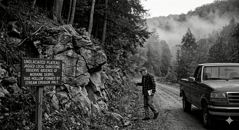
1. Stones: Travelers vs. Locals The clearest evidence of the border lies in creek beds and farmers’ fields. South of the moraine, the rocks are purely local: angular, fractured pieces of local sandstone and shale (like those seen in the unglaciated Image: A Deep, Narrow V-Shaped Valley). North of the line, the ground is littered with smooth, rounded "Glacial Erratics"—exotic travelers like pink granite and dense quartzite that exist nowhere else in Pennsylvania. These smooth stones were rounded by the grinding journey from Ontario.
2. Shapes: Jagged vs. Polished The very texture of the terrain changes. South of the line, the landscape is defined by the "Ancient Cut": steep, sharp, high-relief, jagged "V-shaped" valleys carved only by rain and time (see https://www.google.com/search?q=image_23.png, panel A). North of the line, the landscape exhibits "Ice Polishing": a rolling, gentle terrain of wide, open, smoothed, sanded, and "U-shaped" valleys that were literally sandpapered down by the weight of the moving ice (see https://www.google.com/search?q=image_23.png, panel B).
3. Soil: Rich vs. Rough Finally, look to the farms and forests. South of the moraine, the soil is thin, rocky, and acidic, derived entirely from the decay of local sandstone. North of the line, the glacier left behind "Glacial Till"—a rich, deep, and chaotic mix of crushed Canadian rock and minerals. This imported "black gold" is why agricultural success often improves instantly once you cross the ancient ice frontier.
The Terminal Moraine is more than a line on a map; it is the physical memory of a mile-high wall of ice that reshaped the very DNA of our region, written forever in stone, soil, and landscape.